|
| | Piri Reis Map
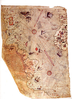 Description: A pre-modern world map that was put together by the Ottoman-Turkish admiral and cartographer Piri Reis. This much we know. The mystery surrounding the half of the map that has survived though is the accuracy in detail that shows the western coasts of Europe, North Africa, and the coast of Brazil. Various Atlantic islands, including the Azores and Canary Islands are shown, as is the mythical island of Antillia and possibly Japan. More puzzling yet though is the inclusion of Antarctica. History books say that Antarctica was not discovered until 1820 by the Russian expedition of Mikhail Lazarev and Fabian Gottlieb von Bellingshausen. Piri Reis’ map was drawn up in 1513. Drawn up on gazelle skin, the map was found in 1929 while Topkapi Palace, in Istanbul, was being converted into a museum. |